Kent Mason – A Pictorial Journey of West Virginia
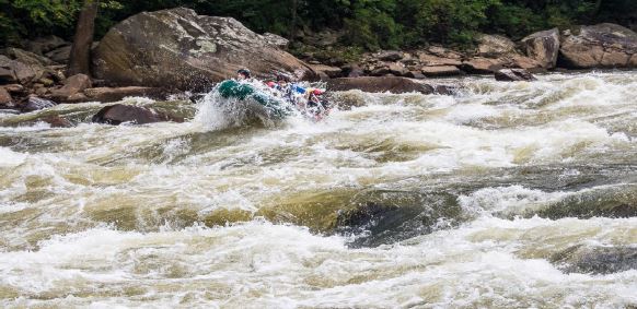
Kent started with his West Virginia winter photos from the highest point in the Allegheny Mountains (that run from Georgia to Main). He then switched to photos of the Cheat River, that runs North from WV to Ohio. Kent ran the river rapids in the bow of an inflatable boat that can carry 8 people; the professional guide steered from the stern. The 7 riders all had paddles to help keep them in the boat. Kent showed a picture of the Cheat in August ’13 when it was very low water and the big rocks in the rapids were exposed. The rapids are graded 1 to 5 in difficulty (based on the height of the water and the water flow). In September 2 boats and a canoe ran 7 Cheat rapids with class 3 and 4 difficulty. Kent did 5 rapids and went ahead down river for two of the most difficult rapids to take pictures as the boats came through the rapids.
Kent started with his West Virginia winter photosfrom the highest point in the Allegheny Mountains(that run from Georgia to Main). He thenswitched to photos of the Cheat River, thatruns North from WV to Ohio. Kent ran the riverrapids in the bow of an inflatable boat that cancarry 8 people; the professional guide steeredfrom the stern. The 7 riders all had paddles tohelp keep them in the boat. Kent showed a pictureof the Cheat in August ’13 when it was verylow water and the big rocks in the rapids wereexposed. The rapids are graded 1 to 5 in difficulty(based on the height of the water andthe water flow). In September 2 boats and acanoe ran 7 Cheat rapids with class 3 and 4 difficulty.Kent did 5 rapids and went ahead downriver for two of the most difficult rapids to takepictures as the boats came through the rapids.